 Here is the latest information from the National Weather Service regarding the potential for heavy rain in Marshall County:
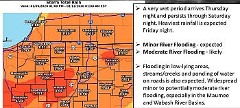
Rain will overspread the area starting Thursday afternoon and continue through Saturday evening, when it may transition to snow and taper off. Rain will become moderate to heavy at times, particularly Friday night and early Saturday.
Rainfall totals Thursday afternoon into Saturday evening look to be around 2 to 4 inches, with locally higher amounts possible. The latest forecasts suggest the highest totals will occur in the Maumee and Wabash river basins, but confidence in the exact location of heaviest rainfall is low at this time. Areal flooding and minor to moderate river flooding is possible.
The Yellow River is currently at 5.38 feet. Flood stage is 13 feet.
Tippecanoe River is currently at 7.86 feet. Flood stage is 12 feet.
Impacts from this event are expected to cause river flooding. Moderate river flooding is likely. Flooding of low lying areas that are susceptible to flooding will occur and ponding on road surfaces can be expected with the potential for some roads to be flood over may make for hazardous travelling conditions.
People living in flood prone locations should move vulnerable property to higher ground, closely monitor the forecast and be prepared to implement their emergency plan. Never drive around road closed due to high water signs. Never drive through high water. Turn around and find a safer route.