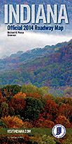
 08/08/13 The Indiana Office of Tourism Development (IOTD) announced today the release of the 2014 Indiana Official Roadway Map. The all-new map is the first partnership of its kind between the Indiana Department of Transportation (INDOT) and IOTD and provides Hoosiers with a single map reflecting INDOT’s roadway accuracy and IOTD’s statewide attraction information.
“This new map is an exciting consolidation of the two existing maps and reflects the great roadways and destinations throughout Indiana,” said Lt. Gov. Sue Ellspermann. “By housing this project with our tourism team, we have eliminated a redundant program while also providing a new outlet for our tourism partners to promote their attractions.”
The 2014 Indiana Official Roadway Map is a combination of two Indiana map programs. In previous years, INDOT produced the official transportation map on a biannual basis and IOTD produced a yearly Indiana travel map. IOTD spearheaded the consolidation of these two maps into one, easy to read product that retains all the functionality of a traditional roadmap while also highlighting many of Indiana’s tourism destinations. The new map will be produced by IOTD on an annual basis.
“By partnering with INDOT to transition production of our state map to the tourism office, we are able to promote Indiana’s tourism partners, destinations and attractions to a wider audience,” said Mark Newman, executive director of IOTD. “From the cover photo to the partners advertised on the map back, this project is a great representation of the beauty, accessibility and travel opportunities that exist throughout Indiana.”
The undulating hills of Crawford and Harrison Counties grace the cover of this year’s map. The image, not often associated with Indiana, is representative of the state’s diverse landscape.
The new roadway map reflects the boom in infrastructure improvements Indiana has undergone in recent years. Among the many new roadway projects on the map: the new Interstate 69 corridor in southwestern Indiana, the Hoosier Heartland corridor and expansion of U.S. 31 in and around Kokomo, both expected to open by the end of this year, and the Fort to Port connection. Additionally, many other projects currently under construction with completion expected in the coming years are noted on the map. These new and future projects provide connectivity throughout all regions of the state and allow travelers within Indiana to safely and quickly reach destinations and attractions.
This year begins a two-year transition to move all production, administrative and sales oversight of the official state map to IOTD. The 2014 Indiana Official Roadway Map will be available at the Indiana State Police and Indiana Office of Tourism Development booths in the expo hall at the Indiana State Fair. As in previous years, maps will also be available at state legislative offices, highway rest stops and state welcome centers. Individuals may also request a new map by visiting IndianasMap.com. The 2014 Indiana Official Roadway Map is free of charge.


